|
||||||||
|
Why using a Sketch for Input Generation? Sketching, particularly freehand sketching, was known by almost all ancient tribes and people who wrote their own history. Neanderthal men sketched their everyday lives on cavern walls, Pythagoras drew his circles into the sands of Greece’s beaches in order to prove his mathematical theories, and still today, sketching is considered a very important skill. The SQbS project seeks to develop the fundamental theories and to render this powerful modality useful to the GIS community. GIS users have a particular need for expressive ways to communicate with computer systems, because they frequently have to describe spatial scenarios. This task is per se more complex than ordinary human-computer interactions, because such problems are in general more dimensional, because information is plentiful, distributed, and extremely heterogeneous, and because geo information tends to change frequently (temporal aspect).
|

|
|||||||
|
Sketching is:
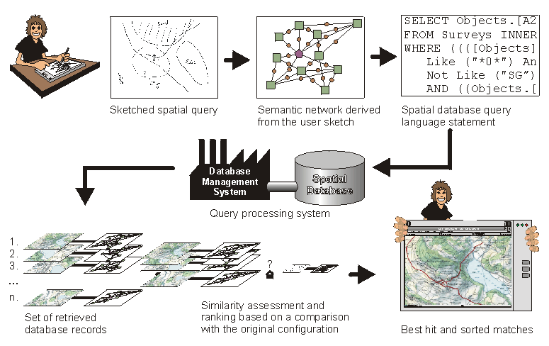
General Concept of SQbS The graphic below shows a schematic concept of Spatial-Query-by-Sketch.
The user draws a sketch directly on the screen of a sketch-based computer. The sketch is interpreted on the fly that is when ever the user adds, deletes, or modifies sketch elements these are analyzed and the internal model of the sketch is updated accordingly. When the user is satisfied with the sketched representation of what he or she is looking for the query button is pressed and the sketch is finalized. The result of this interpretation is a semantic network consisting of the sketched object and a set of relevant relations between them. This formal representation is an abstraction of the sketch and contains all the information that is necessary to search the database for the specified scene. The next processing step involves the translation of the formal model into a spatial query language statement that is then processed against a database. Processing in this context is essentially a similarity assessment of the formal representation of the sketch with information stored in the database. During this step the system seeks to match the topological, metrical, and the directional configuration of the sketch with that of similar sets of objects in the database. The product of this assessment is a ranked set of apparently similar object configurations. Once the results are presented to the user, they can be used as is or they can serve as a base for further queries.
|
||||||||
|
Please refer to our list of
publications
for more in depth information.
[Sketching Survey] [Prototype] [Publications] [People & Organizations] [Related Topics]
|
||||||||
|
||||||||